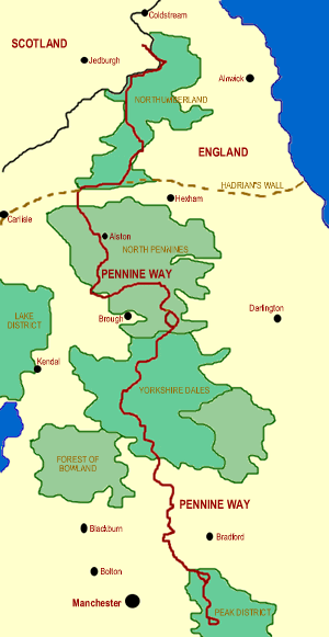
Edale to Kirk Yetholm:
The Grand Old Man of National Trails, the Pennine Way stretches for 270 miles across the spine of England. The walk can be demanding, not least because accommodation can be hard to come by. There are plenty of youth hostels near the path, but PLEASE book before starting to avoid unpleasant disappointments.
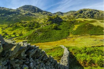
The path begins at Edale in the Peak District National Park, and before it reaches Kirk Yetholm just across the Scottish border it passes through two more National Parks (Yorkshire Dales and Northumberland) and one Area of Outstanding Natural Beauty (North Pennines). NOTE: This is not a walk for novices, and good all-weather gear is essential.
Experienced walkers should allow at least two full weeks to cover the entire length of the path. Water may be hard to come by on the high moors, and temperature can be extremely cold, even in summer. June generally provides the best walking weather, though conditions are VERY changeable, and the wind and rain can always provide unexpected problems.
Youth Hostels
Edale, Crowden, Mankinholes, Haworth, Earby, Malham, Stainforth, Hawes, Keld, Baldersdale, Langdon Beck, Dufton, Alston, Greenhead, Once Brewed, Bellingham Byreness, Kirk Yetholm.
The YHA also has a camping barn at Holwick. The YHA operates a Pennine Way booking service.
Maps
Ordnance Survey maps covering the Pennine Way National Trail:
Explorer OS maps (Scale: 4cm = 1 km / 1: 25000) - best for walking
EX1, EX2, EX16, EX19, EX21, EX30, EX31, EX42, EX43
Landranger OS maps (Scale: 2cm = 1km / 1: 50000)
LR74, LR80, LR86, LR87, LR90, LR92, LR98, LR103, LR109, LR110
All OS maps are available at 10% off retail price, by special arrangement if you order through Britain Express. Both laminated waterproof and plain paper maps are available.
Guidebooks & Accommodation
National Trail Guide - Pennine Way South: Edale to Bowes, by Tony Hopkins, Aurum Press, National Trail Guide - Pennine Way North: Bowes to Kirk Yetholm, By Tony Hopkins, Aurum Press.
Walk This Way: Pennine Way by Peter Gorring, Dilys Cheetham Gotham Press.
Stillwell's National Trail Companion by Tim Stillwell and Dean Conway, Stillwell Publications, - lists accommodation on and near national trails throughout the UK and Ireland
The Rambler's Yearbook and Accommodation Guide published by the Rambler's Association - lists accommodation and walking resources.
The Pennine Way - A new complete guide to walking the Pennine Way, Britain's first long-distance trail. Contains all the essential information you need to complete the trail.
Useful Contacts
Ramblers Association
2nd Floor, Camelford House
87-90 Albert Embankment
London, SE1 7TW
Web: http://www.ramblers.org.uk/index.html
The Pennine Way Association
29 Springfield Park Avenue
Chelmsford, Essex CM2 6EL
Pennine Way National Trail Office
Clegg Nook, Cragg Road
Mytholmroyd, West Yorkshire HX7 5EB
Web site: www.nationaltrail.co.uk/PennineWay/
The Sherpa Van Project is a commercial operator providing baggage transport and accommodation booking for walkers on the Pennine Way.