Antonine Wall, Seabegs Wood
History, tourist information, and nearby accommodation
HERITAGE RATING: 

Antonine Wall, Seabegs Wood
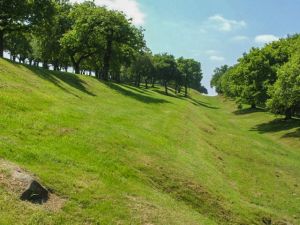
Seabegs Wood is a small Roman fortlet on the course of the 2nd-century Antonine Wall. The remains consist of earthworks, a ditch, and a section of wall standing in attractive woodland.
Seabegs is one of the best places along the Wall to see the defensive ditch and rampart. Connected to the fortlet is a stretch of the Roman military road that linked forts along the Antonine Wall. This is one of the best-preserved sections of road along the course of the wall.
The road ran parallel to the wall and was used for moving troops and supplies. At Seabegs Wood the road is 7m wide with a cambered mound in the centre.
Reaching the fortlet is straightforward. Seabegs Wood is one mile west of Bonnybridge, just south of the Clyde Canal on the B816 road to Castlecary. There is a well-signposted trail to the site.
Most photos are available for licensing, please contact Britain Express image library.
About Antonine Wall, Seabegs Wood
Address: Bonnybridge,
Central Scotland,
Scotland
Attraction Type: Roman Site
Location: On the B816 just west of Bonnybridge
Website: Antonine Wall, Seabegs Wood
Historic Scotland
Location map
OS: NS811792
Photo Credit: Lairich Rig, licensed for reuse under the Creative Commons Licence
Opening Details: Open access site, usually accessible at any reasonable time
HERITAGE
 We've 'tagged' this attraction information to help you find related historic attractions and learn more about major time periods mentioned.
Historic Time Periods:
Roman
Find other attractions tagged with:
Roman (Time Period) -

 We've 'tagged' this attraction information to help you find related historic attractions and learn more about major time periods mentioned.


