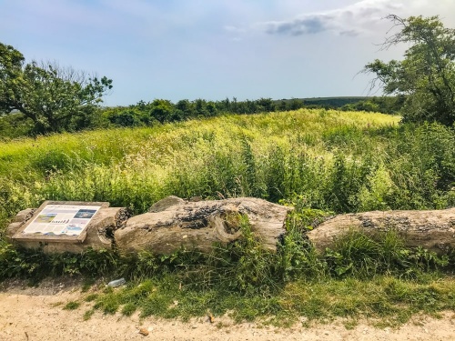
Long Burgh Barrow is a Neolithic long barrow on the hill overlooking the historic East Sussex village of Alfriston. The barrow was erected sometime between 2400 and 3400 BCE. It is a familiar sight for walkers on the South Downs Way National Trail as it lies directly beside the long-distance footpath, a short distance west of the village.
The barrow stands at the junction of the South Downs Way and several smaller footpaths. These trails probably evolved from prehistoric droveways, meaning that the barrow was sited in a prominent place, where it would be seen by large numbers of inhabitants.

Long Burgh is one of the largest barrows in Sussex, measuring 56m long (roughly 180 feet), 28m wide, and rising to a maximum height of 1.8m.
The mound is shaped like a wedge and is aligned on a north-south axis, with its wider end to the north.
Archaeologists suggest that the main chamber was at the northern end of the barrow. This chamber has been badly damaged, possibly by treasure hunters. The mound was investigated by a local landowner in 1767 and a skeleton and pottery urn were found. These have since been lost.

Archaeologists speculate that the burial remains were a later insertion, perhaps dating to the Bronze Age or Saxon period, when the barrow was reused.
The barrow mound is surrounded by two flanking ditches, of which only traces remain. The ditches were formed when chalk to create the mound was dug out of the earth.
The barrow can be overgrown with grass in the summer months, making it difficult to take in the entire structure.
Getting There
Long Burgh Barrow is extremely easy to reach on foot from Alfriston. Simply follow the South Downs Way signs from the High Street. The trail goes up Star Lane and King's Ride, then rises steeply to the summit of the down. It is no more than half a mile (1km) from the village. There is an illustrated information panel in front of the barrow.
About Long Burgh Barrow
Address: South Downs Way,
Alfriston,
East Sussex,
England
Attraction Type: Prehistoric Site
Location: On the South Downs Way, immediately west of Alfriston
Website: Long Burgh Barrow
Location map
OS: TQ510034
Photo Credit: David Ross and Britain Express
HERITAGE
 We've 'tagged' this attraction information to help you find related historic attractions and learn more about major time periods mentioned.
Find other attractions tagged with:
NEARBY HISTORIC ATTRACTIONS
Heritage Rated from 1- 5 (low to exceptional) on historic interest
Alfriston Clergy House - 0.7 miles (Historic Building) ![]()
Alfriston, St Andrew's Church - 0.7 miles (Historic Church) ![]()
Charleston - 2.2 miles (Historic House) ![]()
Westdean, All Saints Church - 2.5 miles (Historic Church) ![]()
Firle Place - 3.3 miles (Historic House) ![]()
Firle, St Peter's Church - 3.4 miles (Historic Church) ![]()
Seaford Museum of Local History - 3.4 miles (Museum) ![]()
Newhaven Fort - 3.4 miles (Historic Building) ![]()


