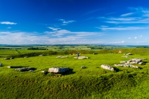
Arbor Low has been called the finest henge monument in the north of England, and the 'Peak District Stonehenge'. The site is composed of a henge monument with the addition of a later stone circle. The outer bank of the henge is roughly circular, measuring about 259 x 246 feet in diameter.
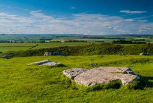
Within the henge bank is a ditch about 6 feet deep and 30 feet wide. The weathered limestone stones are not standing, but lie in a rough circle pointing outwards. There is no firm evidence to suggest whether the stones were originally standing or not; speculation exists that they were knocked down by zealous Christians, but they may also have been laid down by the builders of the circle.
There are 46 large stones, measuring up to 13 feet in length, with 13 smaller stones. At the centre of the circle is a 'cove' of smaller stones; providing a focal point for whatever ceremonial purpose the site was meant to perform. Excavations inside the cove found a skeleton, but it seems likely that this burial was a later addition and not part of the original stone circle and henge arrangement.

A Bronze Age round barrow was later grafted onto the south bank of the henge, using earth removed from the bank. When the barrow was excavated in 1845 a central cist was discovered, with evidence of a cremation burial with pottery vessels and a bone pin.
When was Arbor Low built?
In the Neolithic period, probably around 2500 BC. The Neolithic site was used throughout the Bronze Age so that what we see today is not a simple, single monument, but a ritual site with features covering thousands of years.
Why was it built?
Again, we don't really know, but it seems likely that the henge was simply one part of a much larger ceremonial landscape that included at least 8 chambered tombs and literally hundreds of smaller burial cairns.
Nearby is Gib Hill, a Bronze Age burial mound that may once have been connected to the Arbor Low site by an earthen bank. Gib Hill is built upon a much earlier Stone Age barrow. The hill is man-made and may possibly have been constructed to provide a sightline from Arbor Low.
Arbor Low must be approached through a farmyard with an honesty box for parking payment - be sure to wear good protective footwear!
About Arbor Low
Address: Upper Oldhams Farm, Monyash, Bakewell,
Derbyshire,
England
Attraction Type: Prehistoric Site
Location: half mile off A515
Website: Arbor Low
English Heritage - see also: English Heritage memberships (official website)
Location map
OS: SK160 635
Photo Credit: David Ross and Britain Express
Opening Details: Open access site, usually accessible at any reasonable time
HERITAGE
 We've 'tagged' this attraction information to help you find related historic attractions and learn more about major time periods mentioned.
Find other attractions tagged with:
Bronze Age (Architecture) - stone circle (Historical Reference) -
NEARBY HISTORIC ATTRACTIONS
Heritage Rated from 1- 5 (low to exceptional) on historic interest
Monyash, St Leonard's Church - 1.9 miles (Historic Church) ![]()
Youlgreave, All Saints Church (Youlgrave) - 3.3 miles (Historic Church) ![]()
Bakewell, All Saints Church - 4.6 miles (Historic Church) ![]()
Old House Museum - 4.6 miles (Museum) ![]()
Haddon Hall - 5 miles (Historic House) ![]()
Thornbridge Hall Gardens - 5.2 miles (Garden) ![]()
Winster Market House - 5.4 miles (Historic Building) ![]()
Nine Ladies Stone Circle - 5.6 miles (Prehistoric Site) ![]()


